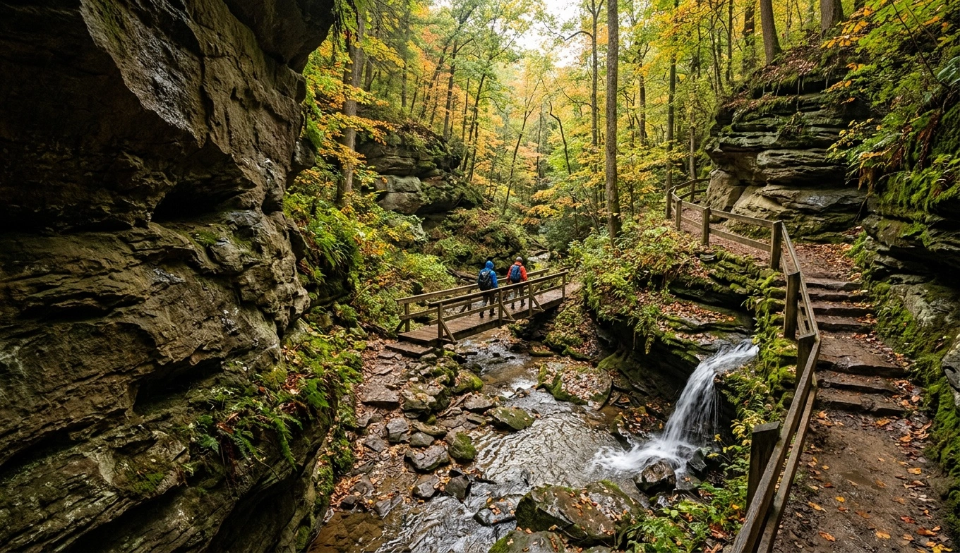
The old man’s cave trail route drops into the gorge near Upper Falls, passes Devil’s Bathtub, and continues through the recess cave to Lower Falls. It suits first-time visitors who want to see the area’s main landmarks in one hike. Expect uneven stone, narrow passages, damp surfaces, and many stairs.
The complete loop covers roughly 1 to 1.5 miles, depending on the return path currently in use. Most visitors need 90 minutes to two hours, and weekend crowds can add time. Follow current directional arrows instead of relying on an old map or reversing your route. Before leaving home, check the Ohio Department of Natural Resources for maps, closures, pet rules, and access updates.
Old Man’s Cave Trail Route Facts
- Approximate distance: About 1 to 1.5 miles for the main loop. Confirm the current signed route with ODNR.
- Route type: A directional loop that uses the gorge trail and a designated return or exit trail.
- Difficulty: Moderate for regular hikers. Stairs, slick stone, and uneven footing may challenge some visitors.
- Typical time: About 90 minutes to two hours. Allow longer during peak crowds or icy conditions.
- Stairs and elevation: Expect repeated stone and wooden stairs, plus a steady climb out of the gorge.
- Parking: Use the main parking area near the Old Man’s Cave visitor center and current trail entrance.
- Dogs: ODNR generally permits leashed dogs here. Confirm current rules and keep pets close near stairs and drop-offs.
- Accessibility: Stairs, narrow passages, rough stone, and elevation changes make the full route unsuitable for wheelchairs and most strollers.
The short mileage can be misleading. Stairs, bridges, tunnels, and narrow sections often slow progress. A fit adult may finish quickly on a dry weekday, while families and mixed-ability groups may need much longer.
Every complete route requires a climb back to parking level. You may find benches in developed areas, but seating along the gorge floor remains limited. Cell service often disappears below the rim, so save the current map and photograph the trailhead map. Always follow posted signs and closure notices over online directions.
Following the Old Man’s Cave Trail Step by Step
Visitor Center to Upper Falls
Start at the designated entrance near the Old Man’s Cave visitor center. You do not need to find a separate Upper Falls trailhead. The approach leads toward the upper gorge, where the creek drops beneath a stone bridge into the sandstone channel.
Current routing may provide a view from above before taking you down to gorge level. Follow each directional arrow, even if another path looks faster. Stone stairs can remain damp after the parking area and surrounding woods have dried.
Upper Falls usually carries more water after sustained rain and during cooler months. Summer flow may shrink after a long dry spell. Pause here before continuing because the route soon becomes narrower and more enclosed.
Upper Falls to Devil’s Bathtub
Below Upper Falls, the trail follows the creek through a tight sandstone gorge. Devil’s Bathtub lies along this section. Moving water carved this deep, rounded pothole into the rock.
View the feature from the designated trail and bridge area. Do not climb down, wade, or enter the water. The pool can conceal deep water, slick rock, and a strong current even when the nearby creek looks shallow.
This stretch includes uneven stone, damp surfaces, and several stairways. Hikers often gather at narrow photography spots, so avoid blocking railings or trail edges. During winter, shaded stone may hold ice long after sunny areas thaw.
Devil’s Bathtub to the Recess Cave
Beyond Devil’s Bathtub, the trail runs between the creek and high sandstone walls. Expect footbridges, carved steps, enclosed passages, and several crossings from one side of the water to the other. Crowds can make this short section take longer than expected.
Old Man’s Cave is a large recess cave, not a deep underground cavern. The marked trail leads through or beside its main rock shelter. Its name honors a hermit associated with the cave through local tradition.
Watch the junction signs carefully. One route may climb toward an exit, while another continues to Lower Falls. If Lower Falls remains part of your plan, check the destination before starting uphill. Repairs and storm damage can change routing, so old screenshots may no longer match the signs.
Old Man’s Cave to Lower Falls and the Return
Continue downstream on the signed trail to reach Lower Falls. This section maintains the enclosed gorge setting beyond the main recess cave. Lower Falls may spread across the rock after wet weather or slow considerably during dry periods.
Stay within designated viewing areas and out of the creek. Wet rock around the falls offers little traction. Near the end of the loop, look for signs directing hikers toward the visitor center and parking area.
Longer trails continue through the Hocking Hills system, including routes toward Cedar Falls. A wrong turn can turn a short outing into a much longer hike. The correct return climbs from the gorge on stairs and uphill trail, so save water and energy for this section.
Once above the gorge, keep following the marked return route. Do not cut across overlooks or use unofficial paths toward the parking lot. Temporary detours may change the exact exit point.
Junctions That Commonly Cause Confusion
Do not assume every uphill trail returns directly to the main parking area. Old Man’s Cave connects with longer park trails, and a wrong turn can add several miles. Read the destination on each sign instead of following the largest group.
Visitors also sometimes take an early exit near the recess cave and miss Lower Falls. To see both waterfalls and Devil’s Bathtub, confirm that your chosen arrow continues downstream. Do not walk backward against posted directions to recover a missed landmark.
Complete the marked route and reassess from the developed area. Reversing direction on narrow stairs creates bottlenecks and conflicts with current trail management. Download or photograph the official map before entering the gorge.
Water Flow, Seasons, and Hiking Times
Winter and spring usually bring stronger flow at Upper and Lower Falls. These seasons also produce slick steps, mud, ice, and occasional high water. Check trail conditions shortly before your visit.
Summer brings dense shade, although waterfalls may slow after a dry spell. Autumn color attracts large weekend crowds. Fallen leaves can also conceal uneven stone, roots, and damp steps.
For easier parking and fewer trail delays, arrive early on a weekday. Traffic rises quickly on mild spring days, October afternoons, and holiday weekends. If the lot is full, use only legal designated parking or return at another time.
Heavy rain can leave puddles, muddy approaches, and wet sandstone even when trails remain open. Winter hikers should carry traction devices and avoid ice-covered stairs. ODNR may close sections because of high water, storm damage, ice, or maintenance.
Children, Strollers, Dogs, and Limited Mobility
Older children who follow directions and handle stairs can usually complete the old man’s cave trail route with patient adults. Toddlers need a secure hiking carrier because the full loop does not accommodate strollers. Keep children close around bridges, drops, damp rock, and low railings.
Visitors with balance problems, knee pain, or limited stamina should look beyond the short mileage. The descent and return climb offer few simple exit choices once you continue into the longer loop. Use a signed shorter exit if conditions exceed your group’s ability.
Keep dogs on a short leash wherever ODNR permits pets. Long leashes create hazards on narrow bridges and stairs. Bring waste bags and drinking water, and remember that wet stone can challenge paws as well as hiking shoes.
Safety in the Gorge and Along the Rim
Stay on designated trails throughout the hike. Park rules prohibit off-trail travel, and the sandstone terrain creates serious hazards. Wet rock offers little grip, ledges can break, and leaves may conceal the edge of a drop.
Some return trails and overlooks cross steep terrain. Barriers reduce risk but cannot replace careful footing and close supervision. Falls from cliffs and rim edges in Hocking Hills have caused serious injuries and deaths.
Never enter pools or creek channels at Upper Falls, Lower Falls, or Devil’s Bathtub. Keep children and leashed dogs away from edges. Do not approach a drop-off for a photograph.
ODNR allows climbing and rappelling only in specifically designated areas. Do not assume the cliffs along this route permit either activity. Wear sturdy shoes with tread, carry traction devices in winter, and obey all closure instructions.
Cell reception remains inconsistent in the gorge. Tell someone where you plan to hike and when you expect to return. Do not depend on a phone to solve an emergency below the rim.
Parking, Facilities, and What to Carry
Park in the designated Old Man’s Cave area near the visitor center. Peak-weekend congestion often begins before midday, so start early. Do not expect overflow parking or shuttle service unless ODNR currently lists those options.
Visitor-center and restroom schedules may vary by season or maintenance needs. Confirm current services before your trip. Carry your own drinking water instead of depending on an open fountain or concession.
Pack water, weather protection, a current map, and basic first aid supplies. Add traction devices whenever freezing conditions are possible. Save the map to your phone and carry a paper copy or trailhead photo as backup.
Check the forecast for Logan and the surrounding park area. The shaded gorge often stays colder and wetter than the parking lot. Before starting, read every temporary notice at the trailhead.
Choosing the Right Version of the Hike
The full old man’s cave trail route links Upper Falls, Devil’s Bathtub, the recess cave, and Lower Falls. Choose this version if everyone can manage repeated stairs and uneven ground for at least two hours. Allow extra time for children, rest breaks, and crowded passages.
If weather, mobility, or crowding becomes a problem, use the current signed shorter exit. Never improvise a shortcut across the creek or reverse direction through narrow passages. Waterfall volume changes with recent rainfall, but the sandstone gorge remains the route’s defining feature.
Before setting out, review current hours, maps, closures, directional rules, and trail conditions. ODNR and Ohio State Parks provide the most reliable updates. Posted instructions at the trailhead take priority when conditions change.










Share This Page