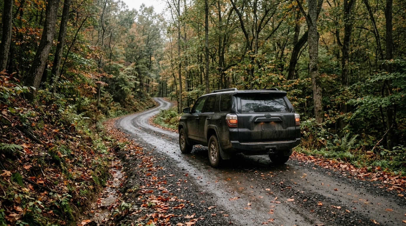
Hocking Hills road conditions can change quickly after heavy rain, snow, or repeated freezing and thawing. Most major park areas have paved approaches. However, cabin lanes and back roads may be narrow, steep, gravel-covered, or unsuitable for low-clearance cars during bad weather.
Stay on state routes whenever practical, and download directions before leaving town. Ask your lodging host what to expect during the final mile. Before driving, check OHGO for highway incidents and the Ohio Department of Natural Resources for park closures and access notices.
What Driving in Hocking Hills Is Really Like
Driving in Hocking Hills is manageable in ordinary weather, but the roads require attention. They follow wooded ridges, creek valleys, and hollows. Expect blind curves, short sightlines, steep grades, and narrow shoulders.
State routes through the region have paved surfaces, including the main approaches to popular park areas. The bigger surprises often begin after you turn onto a county, township, or private road. Two routes may look equal on a navigation app, yet one may include gravel or a steep grade.
Do not treat a posted speed limit as a target on an unfamiliar curve. Slow down further at night, during rain, or when wet leaves cover the pavement. Deer, fallen limbs, farm equipment, cyclists, and stopped vehicles can appear with little warning.
Allow extra travel time. If possible, reach an isolated cabin before dark instead of searching for its entrance at night.
Hocking Hills Road Conditions by Route Type
Road quality varies more by surface and weather than by distance from the park. A paved state route may take a few minutes longer than an app-generated shortcut. It usually provides a calmer, more predictable drive.
The following table describes common conditions, not live road status.
| Road type or destination | What to expect | Main concern | Local advice |
|---|---|---|---|
| State routes serving the park region | Paved roads with curves, hills, and limited shoulders | Blind bends, wildlife, wet leaves, snow, and ice | Favor these routes over unfamiliar shortcuts during poor weather |
| Old Man’s Cave and the main visitor area | A paved approach and a busy park entrance | Traffic backups and full parking during peak periods | Arrive early and follow official parking signs |
| Ash Cave | A paved approach with heavier weekend traffic | Vehicles slowing or turning near the entrance | Watch for signs before the final GPS instruction |
| Cedar Falls, Conkle’s Hollow, Rock House, and Cantwell Cliffs | Paved, winding roads through hilly terrain | Tight curves, short sightlines, and weak phone service | Download maps and allow more time than the mileage suggests |
| County and township roads | Paved, chip-sealed, and gravel surfaces | Potholes, loose gravel, narrow lanes, and drainage damage | Brake before curves and stay on your side of the road |
| Private cabin and campground lanes | Gravel, steep grades, single lanes, or limited maintenance | Mud, ruts, snow, ice, and restricted turnaround space | Ask the property owner for current access details |
Do not assume every named road receives the same level of maintenance. Private lanes can deteriorate after a storm or between guest stays. A road that feels easy in dry October weather may turn slick during a rainy March visit.
Save your host’s written directions as a screenshot. Those instructions may work better than a navigation app for the final turn.
Driving the Main Park Approaches
State Route 664 provides a primary approach from the Logan area toward Old Man’s Cave. The paved road becomes curvier as it enters the hills. Weekend traffic can also build near the park entrance.
Leave extra following distance. Drivers often brake suddenly after spotting a park sign or nearly missing a turn.
State Routes 56 and 374 connect visitors with several hiking areas and local roads. These routes are paved, but they include hills and bends that may feel tight to suburban drivers. Short distances can take longer than expected because many curves require lower speeds.
Never stop in a traffic lane to study a map or photograph the scenery. Continue to a legal parking area before checking directions. Review ODNR notices for park access changes and OHGO for incidents on state roads.
Gravel Roads and Cabin Driveways
Visitors most often encounter gravel near cabins, campgrounds, and vacation rentals. In dry weather, many gravel roads suit an ordinary passenger car. Keep your speed low and avoid deep ruts.
A listing that says “gravel access” may leave out important details. Ask about the grade, lane width, drainage, and turnaround space before booking. Also confirm that a standard sedan can reach the property during your travel season.
Find out whether two vehicles can pass and whether the driveway includes a steep hill. During winter, ask how the owner treats snow and ice. Four-wheel drive may improve traction, but it will not shorten your stopping distance on ice.
Drive slowly enough to avoid throwing stones near homes and other vehicles. Use an established pull-off when meeting traffic on a narrow road. Do not drop a wheel onto a soft ditch edge or enter a private driveway without permission.
Turn around if a road looks unsafe. A line on a GPS screen does not confirm that the route suits your vehicle.
Rain, Flooding, Snow, and Ice
Rain changes Hocking Hills road conditions in several ways. Heavy runoff can move gravel, deepen ruts, carry debris onto pavement, and flood low spots. Never drive through water if you cannot see the road surface or judge the depth.
Winter requires more preparation, especially on shaded roads and private lanes. Bridges, steep grades, and roads between hills can stay icy after streets in Logan or Lancaster clear. Freezing rain often creates more trouble than light snow because ice may look like wet pavement.
Carry a scraper, warm clothing, a charged phone, and enough fuel for a detour. Keep traction devices with your hiking gear for icy trails. Stone steps, sandstone surfaces, and wooden stairs can become extremely slick.
ODNR may close trails or access points because of ice, high water, storm damage, or other hazards. Check current notices instead of relying on yesterday’s plan.
Parking Without Creating a Road Hazard
Parking pressure increases on fall weekends, summer Saturdays, and warm spring days. Old Man’s Cave often attracts the largest early crowds. Smaller lots at other trailheads can also fill quickly.
Arriving early improves your chances of finding a space, but it offers no guarantee. Build parking delays into your schedule during peak periods.
If a designated lot is full, do not park along a narrow shoulder or in front of a gate. Roadside parking can block sightlines, restrict emergency access, and damage soft ground. It also places passengers close to moving traffic.
Choose another official park area or return later. In parking lots, watch for pedestrians and vehicles backing out. Follow posted controls and review current restrictions through ODNR or Ohio State Parks.
Navigation and Cell Service
Cell service varies throughout the hills. A phone may work on a ridge and lose its signal minutes later beside a creek. Download an offline map that covers the whole region, not only your trailhead.
Save your lodging address, written directions, and check-in instructions before leaving reliable service. Screenshot the route between hiking areas as well. Your navigation app may not recalculate after a missed turn.
Keep a paper park map in the vehicle as a backup. It can help you identify nearby state routes and official park areas when your phone has no signal.
Navigation apps often favor the shortest distance, even when smaller roads take longer. Review the full route before driving and favor signed state routes when the options look similar. If you become lost, find a safe and legal place to stop before checking the map.
Gas, Restrooms, Water, and Emergency Planning
Fuel up before spending the day driving between trailheads. Towns offer more dependable access to gas, food, and other services than the wooded roads near hiking areas. A full tank also gives you room to reroute around a closure.
Several major park destinations have restrooms, but hours and availability can change. Some trailheads lack running water or bottle-filling stations. Bring drinking water and check current facility details through ODNR.
Tell someone where you plan to stay and which park areas you expect to visit. This step matters when your group will travel on remote roads or trails. In an emergency, identify the nearest road, intersection, trailhead, or park landmark before calling for help.
A battery pack can keep your phone charged. It cannot create a signal where coverage does not exist.
Choosing a Vehicle for Hocking Hills
Most visitors do not need a truck or sport utility vehicle for the main state park areas. In normal weather, a well-maintained passenger car can handle the paved approaches. Sound tires and working brakes matter more than vehicle size.
Vehicle choice becomes more important when a property uses a steep or rutted private lane. A low sports car may scrape where a sedan clears the surface. A rear-wheel-drive vehicle may also struggle on an icy grade.
Ask the lodging owner about current access shortly before your trip. Conditions may have changed since you booked.
If snow or freezing rain enters the forecast, consider delaying your drive. All-wheel drive cannot make an icy descent safe. Large vehicles may also prove awkward on single-lane roads with little room to turn around.
Whatever you drive, maintain a speed that lets you stop within the visible roadway. This rule matters most near blind bends and hill crests.
Driving After Dark
First-time visitors often underestimate night driving in the region. Roads outside town may have little lighting, and wet pavement can obscure lane markings. Cabin signs may look small, sit far from the road, or face only one direction.
Wildlife creates another hazard after sunset. Use high beams when conditions permit, then dim them for approaching traffic. Scan both sides of the road for deer and other animals.
If you miss a turn, continue until you find a safe place to reverse direction. Never stop or back up near a blind curve.
Try to reach an unfamiliar property before dark. Daylight gives you time to inspect the driveway, locate the correct building, and unload safely. For a late arrival, ask your host for a nearby landmark and confirm that you can see the address marker from your direction of travel.
Seasonal Driving Conditions
Spring brings strong waterfall flow, wet roads, mud, soft shoulders, and occasional storm debris. Heavy rain can also damage gravel lanes. Check the forecast before leaving and avoid flooded roads.
Summer generally provides easier driving conditions. Still, weekend traffic and loose gravel can slow the final approach to a cabin.
Fall adds heavy visitor traffic and wet leaves. Leaves can reduce traction, hide pavement edges, and conceal potholes. Give other vehicles more space and brake before entering curves.
Winter roads may stay quiet on fair-weather days, but shaded ice can persist. Forecasts can also change quickly. Check conditions again on the morning of your trip.
Do not rely on an app’s estimated drive time. Curves, parking delays, missed turns, and gravel lanes can add time. Make sure every driver in your group has the cabin directions.
Pet Rules Near Roads and Trailheads
Check pet rules for each park or preserve before your visit. Hocking Hills State Park and nearby nature preserves may follow different regulations. Conkle’s Hollow is a state nature preserve, so do not assume the state park’s pet rules apply there.
Where officials permit pets, keep them leashed and close. Never let an animal roam near a road or parking area. Also bring water for your pet because trailheads may not offer a dependable source.
A Practical Pre-Drive Checklist
- Check current roads: Review OHGO for incidents, construction, and state-highway closures.
- Check park access: Confirm current hours, closures, rules, and facility details with ODNR.
- Ask about the final mile: Contact your host about gravel, steep grades, winter treatment, and vehicle suitability.
- Download maps: Save offline road maps, park maps, lodging directions, and check-in information.
- Fuel up: Carry enough fuel for a detour or an extended parking delay.
- Carry water: Do not depend on finding a working fountain at every stop.
- Pack for the forecast: Bring sturdy shoes year-round and trail traction devices during icy weather.
- Use legal parking: Visit another official destination if your preferred lot is full.
- Allow daylight: Reach an unfamiliar cabin before dark whenever possible.
A few minutes of planning can prevent most driving problems. Stay on designated routes, slow down before curves, and know what to expect after the pavement ends.
Plan a Safe Hocking Hills Drive
Treat the final portion of the trip as a rural drive, not an extension of the highway. Add time and keep your attention on the road. Let faster drivers pass only where you can do so safely and legally.
Main park access suits most drivers in ordinary weather. Gravel lanes usually require patience rather than a specialized vehicle. Weather, private-road maintenance, and temporary closures deserve a fresh check before every visit.
Review Hocking Hills road conditions before leaving home. Use OHGO for current state-road information and ODNR for park hours, closures, trail conditions, and access rules.









Share This Page